In Search of Accurate Geospatial Data Sets: Using technical skills to support equitable distribution of place-based technologies
By Ivone Masara and Marisa Duarte
As community-centered tech researchers, we are learning a lot about how geospatial data sets shape the innovation of rural place-based information and communication technologies (ICTs). Especially with Internet-enabled systems, designers can apply up-to-date geospatial data sets to improve performance of place-based technologies, and discern constraints shaping end-user engagement. Through these methods, GIS-enhanced systems can help marginalized communities overcome structural inequities. (Srinivasan, 2019)
Maps can be a tool in the fight for our rights: visualizing geospatial distribution of resources
Maps are integral tools for communities shaping behaviors around place-based infrastructures. In addition to dashboards, graphs and charts, maps depict geospatial distribution of resources. Layered with the right social, economic, and geographical data, maps provide location intelligence to inform businesses, resource management, optimal development routes,
disaster management and other crucial structures in our society. Our team has examined maps that help technicians decide where to lay fiber optic cables that make 2.5 GHz connection speeds a reality, maps that health workers use to track the spread of COVID-19 across hospital service regions, and maps that help Internet service providers decide where to place public wifi hotspots.
As technology researchers, we coordinate various data sets with geospatial information to observe trends, frame anecdotal evidence, and communicate our findings. However, to make maps, geospatial data sets have to exist in accessible formats, including accurate and precise locational coordinates, timestamps, and other such information. They have to have been methodically collected by a reputable research team over time. Prior research suggests that is why maps are so popular in technologically advanced countries and regions and less likely used in developing countries and regions; GIS data collection tools are more accessible and available in technologically advanced countries, as are the personnel equipped to implement mapping.
Thus maps are more than just a tool for visualization. When it comes to Indigenous planning and development, maps are a tool in the fight for rights. (Bryan & Wood, 2015) They can tell us where we need more schools for public education; water for drinking, ecological restoration, and agriculture; and trees for a healthy environment. Maps help us plan the distribution of resources towards promoting social equity.
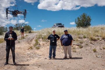
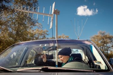
Our team grapples with these concerns in a few different ways. We have ideas for useful public interfaces, such as digital maps to inform Internet infrastructure planning and policy-making, and mobile apps with visual functions to support spectrum-sensing. More specifically, to support our smart middle-mile infrastructure objectives, we have been trying to assemble accurate geospatial data sets associated with Internet connectivity and coverage in Indian Country, particularly through rural counties and sovereign Pueblos of northern New Mexico, and with regard for ranges of spectrum that can channel signal through TV white space Internet base stations. We discovered that specific ranges of spectrum which we expected to be available are in fact being used, though it is unclear how they are being used and by whom. Making this information publicly available is important because spectrum is arguably a natural resource that falls within the territorial and regulatory jurisdiction of sovereign Native nations. Making this information publicly available helps tribal network professionals reserve technical space for local innovation, and researchers like ourselves partner to think of novel ways to extend existing infrastructure beyond the corporate telecom influence.
The complications of access: the challenge of sharing, managing, and using geospatial data
When it comes to distributing integral resources to underserved communities, the quality of geospatial data sets really matters. Usually, good quality, informative, actionable data sets are logistically difficult and expensive to assemble and create. This is a challenge for those in economically developing countries and regions.
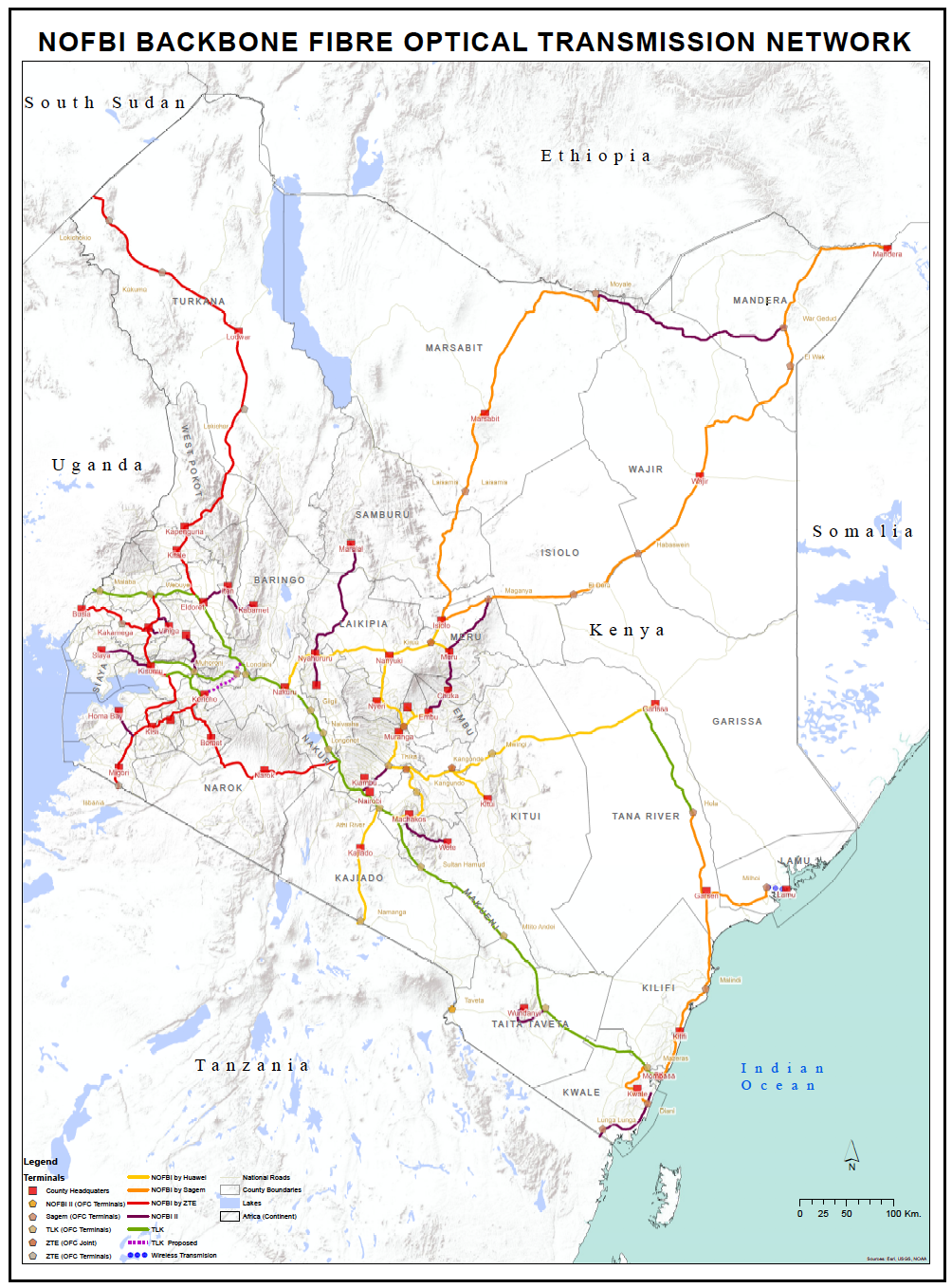
While we were looking for regional rates of Internet connectivity in Indian Country, we also sought information about regional rates of Internet connectivity in Kenya. Similar to Indian Country, Kenya consists of large regions of rural and remote terrain where, we hypothesize, that communities rely on anchor institutions for their Internet connection. We were hoping to find geospatial data sets that might indicate points of similarity regarding Internet access and connectivity in contexts that a) have comparable physical geography, b) withstand contemporary and historical patterns of colonization, and c) pursue economic development strategies, including investments in community-based ICTs. In the case of Kenya, though there is a national fiber optic network (NOFBI) with an open data fellows program, we found that currently there is no public domain that shares interactive uniform data sets about Internet connectivity, which should ideally be the base of any national Internet and telecommunications agenda, and could include information about administrative boundaries, location of public amenities such as schools, chiefs’ camps or schools, and hospitals.
Furthermore, our experience working in Indian Country has been that acquiring detailed data sets through government can be, for a non-researcher, an excruciatingly long process, and for a trained researcher, a process in establishing mutual trust and privacy around shared data sets. In the case of Kenya, though one of our team members is a citizen, being out of the country complicates the ability to establish access and use agreements. Often, one has to be associated with a school or personally know the collector of GIS data sets. Moreover, in both Indian Country and in Kenya, our experience has been that most data sharing is done through informal means such as via Excel spreadsheets through Dropbox or Google Drive, and also sans metadata, such that one can’t ascertain the source, time/date of collection, or the method of acquisition. Such data sets are usually not designed to be shared publicly or widely among researchers.
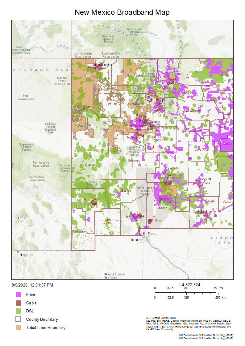
Often GIS research facilities in economically developing countries and regions are not well funded or maintained, leading to insufficient data storage, security, maintenance, synchronization, and access. In these contexts, data sets may be the outcome of a one-time investment in land-based or infrastructural research, and so are intended for a very narrow use. Most governments in developing countries and regions are now trying to digitize their records toward better storage, access, and synchronization. A good example of routinizing GIS data sets is found in the Ministry of Lands in Kenya, which is creating a digital database for both public and private land records. The database will go a long way in reducing land conflicts and corruption, and in increasing public understanding of land transactions. Our team also relies on the dedicated work of the New Mexico Broadband and Geospatial team, which produces the New Mexico Broadband Map. In spite of efforts like these, it still takes skill and patience to meaningfully acquire, arrange, synthesize, share, and analyze geospatial information toward local technology solutions.
How patterns of colonization complicate access to geospatial data
Secure public access to methodically maintained geospatial data sets is fundamental to economic self-determination and the protection of Indigenous sovereignty. Such access allows researchers to conduct analysis that informs public policies, governments, schools, and business development toward the equitable distribution of infrastructure. This is particularly important for countries and nations with expanses of rural and remote terrain containing desirable natural resources, and whose leaders must resist the informatic colonialism of tech-empowered entrepreneurs.
Ubiquitous and systematic collection of geospatial data is a somewhat intangible aspect of daily life in technologically advanced countries and regions, especially in urban settings. Many urban residents take for granted the terrestrial fiber-optic cables that power their wifi and fuel their hopes for 5G. When only the wealthy elite of a country are able to access high-speed Internet and geospatial data sets, it gives them an informatic power over groups who are not able to defend their rights to territory, natural resources, and public infrastructures. This gap in technical access and information empowers venture capitalists and others to speculate on the value of land and associated infrastructures like fiber-optic routes, roadways, pipelines, and spectrum blocks. If you are a person who comes from an economically developing country, region, or sovereign Native nation, then you may understand how it takes a whole community working together to support the educational and professional efforts of a few who can strengthen their technical skill and social capital to improve the community’s public infrastructure. It is a generational effort to co-construct community-centered Internet infrastructure. Geospatial skill is one part of the planning effort.

Bryan, Joe and Denis Wood. (2015) Weaponizing Maps: Indigenous Peoples and Counterinsurgency in the Americas. Guilford Press.
Srinivasan, Ramesh. (2019) Beyond the Valley: How Innovators Around the World Are Overcoming Inequality and Creating the Technologies of Tomorrow. MIT Press.